
Frequently Asked
Questions
GENERAL
HOW OFTEN ARE THE H2NOW GAUGES UPDATED?
The Proteus sondes take measurements every 15 minutes, and the H2NOW water quality gauges on the homepage of the website are updated in near-real time.
WHY ARE SENSOR READINGS DIFFERENT AT EACH MONITORING SITE?
Tryptophan-like fluorescence (TLF) readings are different at each monitoring site, as can be clearly observed on the plot below.
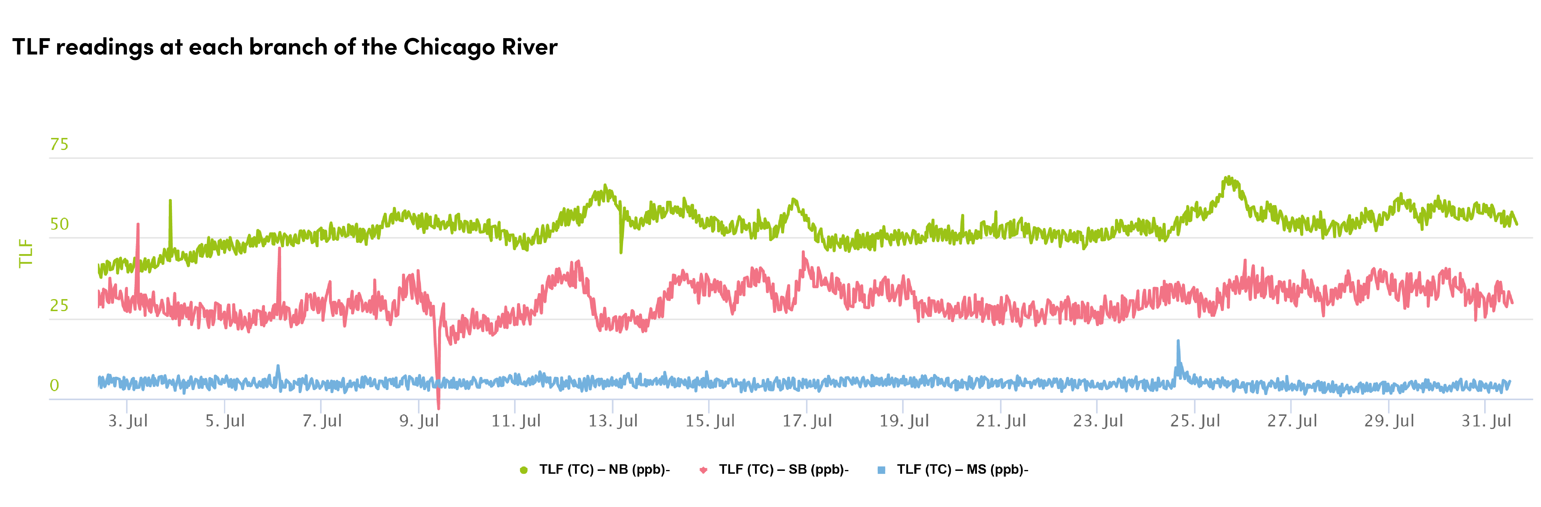
Values of other parameters, such as specific conductivity, colored dissolved organic matter (CDOM), temperature, and turbidity, also differ from site to site.
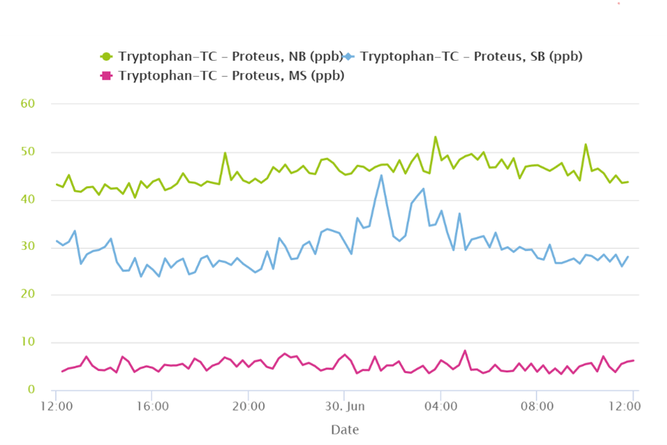
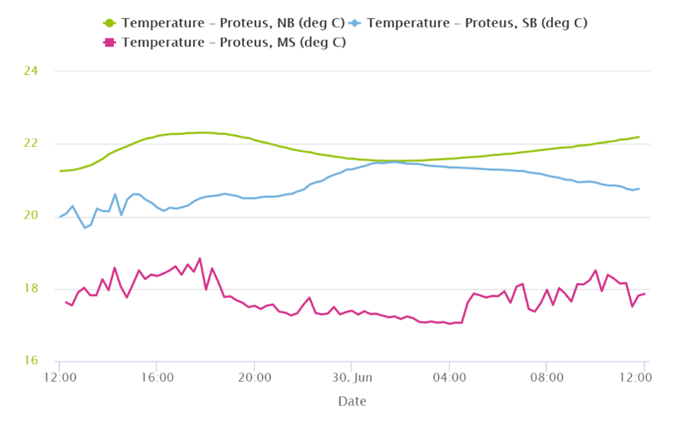
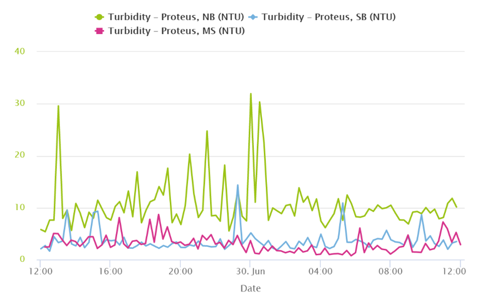
There are several factors that can be causing these differences. Some of them include:
- Different channel geometry (different average depth and width). The North Branch is the shallowest and narrowest of the three and, therefore, experiences higher flows, which may be the reason why turbidity is generally higher on the North Branch. . Water temperature is also slightly higher on the North Branch, likely because the water is quicker to warm up due to this stretch being shallower.
- Different sources of water. The North Branch water is highly influenced by treated wastewater, which is discharged by the O’Brien Water Reclamation Plant into the North Shore Channel. The plant treats wastewater to the required standard and then disinfects it, but some of the remaining organic and inorganic constituents may be responsible for the higher TLF, CDOM, and specific conductivity measurements. The Main Stem water comes from Lake Michigan, which is the source of drinking water to the City of Chicago and many surrounding communities. Lake Michigan water is colder than that of the river and it is also visibly clearer. This is why the Main Stem sensors show lower temperature and turbidity. TLF, CDOM, and specific conductivity readings are also much lower on the Main Stem than on the North Branch. The South Branch combines the flow from the North and South Branches and, not surprisingly, its sensor readings typically fall somewhere in between the two other Chicago River locations.
- Different uses. The North Branch is typically used by kayakers and small boats, while the Main Stem and South Branch are designed for commercial navigation. In the spring, summer, and early fall, the Main Stem is heavily used by large tourist boats and smaller recreational boats, which raises turbidity.
- Different surroundings. The effect of varying surroundings on water quality is hard to underestimate. In urban areas with an abundance of impervious surfaces and lack of adequate drainage, stormwater runoff may pollute the river. More natural areas will attenuate (soak up) the effect of stormwater runoff. Industrial and commercial areas may introduce industry-specific pollutants, such as heavy metals and PFAS. One thing that all three branches of the Chicago River have in common, though, is the abundance of sewer outfalls (close to 200 total). When sewers fill to capacity, they will spill into the river to prevent urban flooding.
WHERE IS H2NOW MEASURING WATER QUALITY?
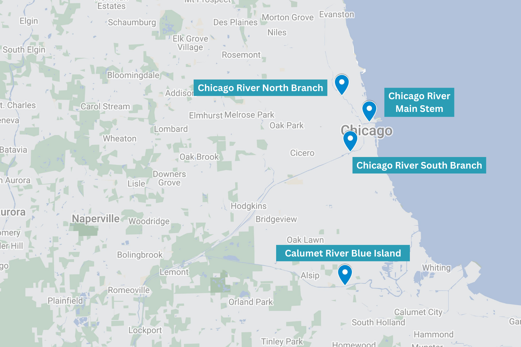
Four real-time water quality monitoring probes have been placed in the North Branch, Main Stem and South Branch of the Chicago River and in the Cal-Sag Channel of the Calumet River. The North Branch location is upstream of Goose Island; the Main Stem location is upstream of Michigan Ave; and the South Branch location is upstream of the Eleanor Boat House. The Calumet River location is downstream of the Division Street bridge.
PROGRAM GOALS AND HISTORY
WHAT IS H2NOW CHICAGO?
H2NOW Chicago is like a weather app for the Chicago Area Waterway System (CAWS). It estimates real-time microbial water quality conditions along all three branches of the Chicago River and in the Cal-Sag Channel of the Calumet River (see map). The types of sensors H2NOW uses, allowing for the communication of real-time data, are relatively new technologies. To date, monitoring of river bacterial water quality has been accomplished by sending river samples to a lab and waiting at least a day for the results. With H2NOW, the river’s variable water quality can be tracked every 15 minutes, a big improvement for everyone who wants to interact with and enjoy Chicago’s rivers.
Current uses the H2NOW Chicago platform to pilot new technologies in real-world conditions. Our goal is to support the development of water quality technologies to reduce risk, allowing for faster commercialization and adoption. Derisking technologies is important, as the interest from other communities and organizations in using novel technologies grows.
WHAT INSPIRED H2NOW?
Chicago’s rivers are one of our region’s greatest assets, but like many urban rivers, they need to be restored from years of heavy industrial use. In 2016, a major community planning called Our Great Rivers was launched with the goal of making the Chicago, Calumet and Des Plaines Rivers into desirable, accessible destinations for all residents to use for recreation and economic development. Gathering and sharing real-time information about river water quality was a goal set forth in the Great Rivers vision.
WHAT ARE THE GOALS OF H2NOW?
Our goals are:
- Collect Real-Time Water Quality Data: Collect data every 15 minutes in order to monitor real-time shifts in water quality.
- Make Water Quality Data Accessible: Publish microbial water quality assessments on our public website and make our historic datasets on the Chicago and Calumet rivers easily accessible to assist the public in making informed decisions about how they interact with the water.
- Analyze Factors that Influence Water Quality: Analyze how water quality changes due to natural events (rainfall, lake diversion) and human activities (combined sewer overflows).
- Public Education & Engagement: Raise awareness of river health and water quality to foster a deeper public connection to Chicago’s waterways. Enhance public engagement with the rivers, driving sustainable development - from recreational providers to real estate developers.
- Support Innovators & Commercialization: Further Chicago's reputation as a water innovation leader. Serve as an open-water testbed for new technologies, by piloting and validating innovative tools. We were the first U.S. city to monitor and publicly communicate real-time microbial water quality data, and have used our expertise to support the development and launch of similar programs across the U.S.
HOW IS H2NOW LINKED TO LARGER SUSTAINABILITY EFFORTS?
The H2NOW project is rooted in goals of sustainability, discovery, and transparency. The below documents informed the design of this project, particularly the Our Great Rivers vision, which established a 2020 goal for real-time water quality monitoring in Chicago's rivers.
FECAL COLIFORMS
WHAT ARE FECAL COLIFORMS?
Fecal coliforms are bacteria that originate from warm-blooded animal feces, including humans, and can spread in waterways from large events, like sewage overflows or less conspicuous point sources, such as surface runoff that picks up animal feces left on the ground. They are members of two bacteria groups: coliforms and fecal streptococci. Many are not harmful to humans, but they are used by scientists and regulators as indicator organisms because they can alert us to the potential presence of other disease-causing bacteria, viruses, and protozoans living in the water.
WHY ARE FECAL COLIFORMS MEASURED?
H2NOW is monitoring fecal coliforms because portions of the Chicago River and the Calumet River are regulated for Primary Contact Use by the IEPA. The water quality regulation for protected waterways is based on a minimum of five water samples taken within a 30-day period. For these five samples, fecal coliforms should not exceed a geometric mean of 200 CFU per 100 ml of water, nor shall more than 10% of the samples taken during any 30-day period exceed 400 CFU per 100 ml of water. (35 Ill. Adm. Code Section 302.209). This water quality standard is the basis for the H2NOW microbial water quality assessment.
WHAT ARE CFUS?
CFU is an abbreviation for “Colony Forming Unit”. It is a term often used to measure bacteria, like fecal coliforms, in water. Simply stated, CFUs are the number of bacterial colonies or clusters visible in a sample after testing (see the image below). CFUs are typically reported for a 100 mL volume of a sample.
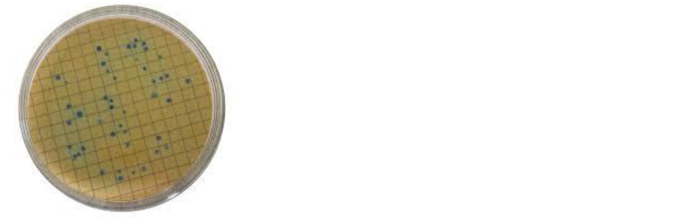
Source: USGS, 2017.
WHY ARE THERE FECAL COLIFORMS IN THE WATER?
Fecal coliform bacteria may occur in open waters, such as rivers and lakes, as a result of several factors: sewage overflows, waterfowl, stormwater/nonpoint sources of human and animal waste accumulated through runoff, and sediments, which may be stirred up by boats . This means that the levels of fecal coliform in the water can be elevated, even without a combined sewer overflow event.
TECHNOLOGY
WHAT ARE THE TECHNOLOGIES USED AND HOW DO THEY WORK?
While we are currently piloting Virridy’s Lume sensor at six locations in 2026, all of the data directly displayed on the H2NOW website is from the Proteus Multiparameter Sondes.
Please see the Technologies page for more details.
WHAT DOES H2NOW CHICAGO MEASURE?
H2NOW uses multiparameter sondes from Proteus to measure river temperature, turbidity (how cloudy or clear the water is), specific conductivity (salinity), colored dissolved organic matter (CDOM), and tryptophan-like fluorescence (TLF).
DOES H2NOW MEASURE FECAL COLIFORMS?
The Proteus multiparameter sondes do not directly measure fecal coliforms. Instead, the sensor data, collected and transmitted every 15 minutes, is put through a machine learning algorithm that estimates fecal coliform numbers at each site and produces a water quality assessment. This assessment is then displayed on the gauges on H2NOW’s homepage, which estimates the level of caution the public should exercise when recreating on the river (good, low caution, or high caution). The fecal coliform tests conducted monthly during the recreational season help verify and adjust the model, if necessary, in order to deliver to the public the most accurate assessment possible.
WHY DOES H2NOW CHICAGO USE TLF AND CDOM SENSORS?
TLF is an optical sensor that emits and detects electromagnetic frequencies associated with fluorescence of the amino-acid tryptophan. More simply put, it uses a specific type of light to detect a protein common in cells. Because of that, researchers have investigated its ability to estimate concentrations of microbes in water. CDOM is similar to TLF, but it deploys a different type of light , more strongly associated with the natural organic matter in water (like decaying leaves and plants).
TLF, together with CDOM and temperature, is used by Proteus and H2NOW to estimate fecal coliform levels in the rivers. The water quality model has improved every year since launching H2NOW in 2021 as we learn more about how the parameters that we monitor interact with one another.
*Other references:
1. Jade S.T. Ward, Daniel J. Lapworth, Daniel S. Read, Steve Pedley, Sembeyawo T. Banda, Maurice Monjerezi, Gloria Gwengweya, Alan M. MacDonald, Tryptophan-like fluorescence as a high-level screening tool for detecting microbial contamination in drinking water, Science of The Total Environment, Volume 750, 141284.
2. Bedell, E., Sharpe, T., Purvis, T., Brown, J., Thomas, E. (2020) Demonstration of Tryptophan-Like Fluorescence Sensor Concepts for Fecal Exposure Detection in Drinking Water in Remote and Resource Constrained Settings. Sustainability. V. 12, 3768; doi:10.3390/su12093768
WHAT ARE FECAL COLIFORMS AND WHY ARE THEY MONITORED?
Fecal coliforms are bacteria that originate from warm-blooded animal feces, including humans, and can spread in waterways from large events, like sewage overflows or less conspicuous point sources, such as surface runoff that picks up animal feces left on the ground. They are members of two bacteria groups: coliforms and fecal streptococci. Many are not harmful to humans, but they are used as indicator organisms because they can alert us to the potential presence of other disease-causing bacteria, viruses and protozoans living in the water.
Engaging with water that has high levels of fecal coliform bacteria increases your chance of developing a mild illness, such as: gastrointestinal symptoms of vomiting and diarrhea; respiratory problems like colds, coughs and sore throat; eye redness and irritation; ear pain or ear infection; and skin rash. These occur when pathogens enter the body through the mouth, nose, ears or cuts on the skin. The U.S. EPA uses fecal coliform bacteria as indicator organisms to identify potential human health risks in a body of water.
H2NOW is measuring fecal coliforms because portions of the Chicago River and the Calumet River are designated for Primary Contact Use by the Illinois Environmental Protection Agency (IEPA). That means that the rivers are designated for recreational use, and the water quality regulation for FCs is that based on a minimum of five samples taken within a 30-day period, FCs should not exceed a geometric mean of 200 per 100 ml of water, nor shall more than 10% of the samples during any 30-day period exceed 400 per 100 ml of water, in protected waterways. ([35 Ill. Adm. Code Section 302.209] 5). This water quality standard is the basis for the H2NOW microbial water quality assessment.
DOES THE H2NOW TEAM COLLECT WATER QUALITY SAMPLES TOO?
To evaluate the real-time water quality model, we need to compare lab-based fecal coliform measurements with estimated fecal coliform values produced by Proteus’ proprietary machine learning algorithm. On a monthly basis while the H2NOW sondes are in the water, we collect water samples from each monitoring site and send them to an analytical laboratory for fecal coliform analysis.
To collect the samples, the H2NOW sampling team uses a specialized sampling apparatus and a carefully designed procedure to ensure quality control of the samples. The samples are collected as close to the Proteus sonde as possible, using sterile bottles. Once the samples are collected, they are placed on ice and transported to an EPA-certified analytical laboratory within 6 hours of collection. The EPA-certified analytical laboratory uses the membrane filtration method for fecal coliforms to quantify the bacteria in the water (SM-9222D). The results are ready in 24-48 hours, depending on how much bacteria is in the samples. TThe lab results are used to continuously evaluate the fecal coliform algorithm’s performance and calibrate the model to improve its precision as needed.
RECREATION
HOW EXACTLY IS RECREATION (E.G., SWIMMING, KAYAKING, ETC.) WATER QUALITY DETERMINED?
The Illinois Environmental Protection Agency (IEPA) states that based on a minimum of five samples taken within a 30-day period, fecal coliforms should not exceed a geometric mean of 200 per 100 ml of water, nor shall more than 10% of the samples during any 30-day period exceed 400 per 100 ml of water, in protected waterways. (35 Ill. Adm. Code Section 302.209)
CAN I GET SICK IF I TOUCH THE RIVER WATER?
While residents of Chicago are not legally allowed to swim in the Chicago rivers, people may directly encounter the water during recreational activities like kayaking, rowing, canoeing, fishing, or motor boating. A study conducted in 2011 found that the risk of becoming sick with a gastrointestinal illness was higher for people who engaged in activities in or near the Chicago River compared to those who did not engage in any activities on the water at all. The risk was about the same for people who used Lake Michigan for recreation. In 2016, the Metropolitan Water Reclamation District of Greater Chicago began disinfecting treated wastewater that enters the North Branch of the Chicago River using a chemical-free method. This resulted in much lower fecal pollution levels than at the time of the study.
CAN I SWIM IN THE CHICAGO AND CALUMET RIVERS?
The Chicago Area Waterways are not designed for swimming. The investments the Metropolitan Water Reclamation District of Greater Chicago has made in protecting our waterways has yielded positive results, cleaner waterways, and a surge in recreational activity and economic development. However, like all natural bodies of water, our river contains wildlife and bacteria. Anyone considering contact with natural water bodies such as the Chicago Area Waterway System (CAWS) should consult with their physician. Although water quality is improved, many hazards exist on the waterways due to boat traffic, currents, temperature, and lack of ingress and egress to name a few.
COMBINED SEWER OUTFLOWS (CSOs)
WHAT IS A COMBINED SEWER OUTFLOW (CSO) AND HOW DO I KNOW ONE HAS OCCURRED?
A Combined Sewer Overflow (CSO) is when a sewer system that collects stormwater and sanitary sewage in the same pipe, like in Chicago, receives more water than it can hold, leading to the combination of stormwater and raw, untreated sewage being diverted to an open-water body. In Chicago, CSOs typically occur when heavy rain sends a large volume of stormwater into our wastewater pipes and overwhelms the holding capacity.
The early Chicago sewer system, like most sewer systems of its time, was built primarily to carry human waste away from the city and was not designed for either stormwater influxes or for servicing this many residents. Today, influxes of stormwater can cause sewage to spill into waterways. Although the MWRD’s Tunnel and Reservoir Plan (TARP) has significantly reduced the number of CSOs, they still occur during heavy rain events.
HOW DO I KNOW WHEN A CSO HAS OCCURRED?
CSOs result in an uptick in fecal coliform in the Chicago River due to contamination from sewage.. If the CSO occurs close to one of the H2NOW sites, you may notice that the H2NOW gauge is showing a higher degree of caution than is typical for that site. However, there is no guarantee that a CSO that occurs upstream or downstream of an H2NOW site will be captured by the gauges.
For regulatory purposes, the Metropolitan Water Reclamation District of Greater Chicago (MWRD) keeps a public record of when and where a CSOs occurs on its website. You can sign up to be alerted in near real-time when a CSO occurs at https://geohub.mwrd.org/pages/cso.
*References:
Dorevitch, Samuel. Chicago, IL, 2011, The Chicago Health, Environmental Exposure, and Recreation Study